The Cordillera Blanca is an impressive mountain range within the Peruvian Andes that sets itself apart from the rest for its great height and extensive glaciation (hence the name). It is located less than 10 degrees south of the equator, which makes theses masses of ice and snow look somewhat out of place (and very vulnerable to global warming). It is also home to Peru´s tallest Mountain (Huascaran Sur, 6768m) and a paradise for climbers and trekkers. Naturally we had to pay it a visit, sooner or later.
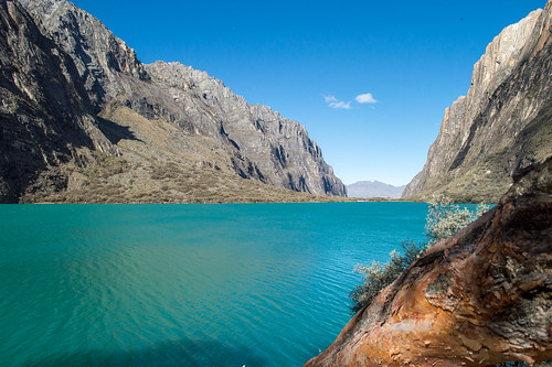
The hub for exploring the Cordillera Blanca is a town called Huaraz, located approximately 3100m above sea level, where most visitors spend a few days to start acclimatising to the altitude. It didn´t strike us as a particularly pretty or memorable place, but it has a couple of semi-decent accommodation and restaurant options, which is convenient. From Huaraz, one can easily go on various day hikes and short trips. We made it to Laguna 69 on our second day, a pretty blue lagoon at a base of a glacier located 4500m above sea level.
 |
| Patricia taking a quick dip in the freezing cold Laguna 69 |
The principal objective of our visit to the Cordillera Blanca, though, was a multi-day trek which we wanted to attempt. There are many different options and variations of treks one can choose from, we opted for the 4-day Santa Cruz Trek, crossing the mountains from west to east, starting at Cashapampa (meaning "plane full of needles" in Quechua) and finishing at Vaqueria.
Santa Cruz is probably the most popular route (often also done in the reverse direction, east to west), which means one does bump into groups led by agencies every now and then and mules carrying their gear. As a side note, if you are thinking of doing this with an agency, please go with the expensive ones... there were lots of mules carrying way too much gear - some of them even fell on the floor :(((( It is your gear, you carry it or at least should be concerned for the well-being of those helping you carry it.
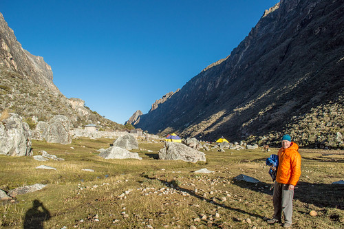
To get to Cashapampa on the first day we caught a colectivo from Huaraz to Caraz and a taxi from Caraz to Cashapampa, where the hike starts at about 2900m, above sea level. After signing in with the National Park Authority, one follows a gently climbing trail, which takes one up to the first camp at 3700m over the course of 5 hours or so.
 |
| Taking a breather in the shade (check out the bromelia growing on the tree in the background!) |
 |
| The base for the first night |
The theme continues on the second day, climbing up the valley further to almost 4200m, at which point several 6000m peaks popped out of the clouds around us. We pitched our tent again quite early in the afternoon at the Jatunquisuar campsite, leaving time for a side-trip (without our heavy packs) up another valley towards the Alpamayo Base Camp and Laguna Arhuacocha at 4500m.
 |
| Side trip to Laguna Arhuacocha in the afternoon of day 2 |
Day 3 is the hardest one, for having to cross a pass of 4750m, the highest point of the trek. That day we were thinking more than once that there is probably an argument for doing this trek with an agency and having your luggage conveniently transferred from camp to camp by means of mules… but hey, no pain no gain! q-;
 |
| Crossing the Punta Union pass (4750m above sea level) |
Once over the pass one reaches the last camp within another two or three hours descending back to 3800m, leaving only a relatively short last day before getting back to civilization (i.e. a couple of small villages from where one can catch a colectivo back to Huaraz).
Those four days in the mountains were no doubt quite hard, mainly for having to carry our packs to considerable altitude, but the views more than made up for the suffering we had to endure. A very beautiful trip and nice introduction to the Cordillera Blanca! A few more photos in below slide show (or in higher resolution here):
No comments:
Post a Comment