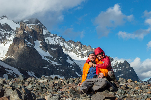
Just like in previous years, we took some time out at the end of December for a little holiday in the South of Chile. We only had a rough plan: start with a trek in Cerro Castillo National Reserve in Central Patagonia, thereafter travel overland back North, all the way back to
Puerto Montt. This post will be about the trek (more about the rest of the trip will follow in another post in January).
Cerro Castillo is an iconic jagged peak off the
Carretera Austral, about 60 km south-west of
Coyhaique. The area surrounding it has been protected as a National Reserve since 1970, but apart from a few hardcore climbers it hasn't attracted much visitor traffic since then. Only in recent years it has started developing into an alternative hiking destination to the increasingly crowded
Torres del Paine National Park.
 |
| Cerro Castillo - elevation 2675m asl |
Most of the Chilean part of Patagonia is notorious for its crazy weather, with very high winds especially during the summer months, and the possibility of heavy downpours (and snow in the elevated parts) pretty much any day of the year. So when the week before Christmas the possibility of a 4-day window of nice(ish) weather emerged in the forecast, we pretty much dropped what we were doing and got on the plane to Coyhaique, a week earlier than we had originally planned.
The trek we had laid our eyes on, the
Cerro Castillo Traverse, is probably in the same league as the much more famous
"W" in Torres del Paine. The tourist infrastructure in the area, though, is still much more basic. The closest village, Villa Cerro Castillo, consists of a couple of streets, some cabins and a "super"market (that you need to knock on the door so they open it for you!) :op Getting there or back may have to involve some hitchhiking as public transport is relatively sparse.
The trek is approximately 50km long, crosses 3 different Patagonian valleys which take you through pampas, rivers, forests, rock and snow, and it takes most people three to four days to complete it. There is an incredible wealth of colour and landscapes including blue and white glaciers, emerald lakes, clear and silty rivers, Coihues, Lengas and Ñirre trees (all belonging to the
Notofagus genus, also known as the southern beech) and incredible rocky outcrops which are a direct result of receeding glaciers.
We started the trek at a point called Las Horquetas. This makes sense as the trek gets more and more interesting as you walk (starts easy, relatively flat and with some pampa and river crossings)
 |
| Our lunch spot on day 1 |
 |
| One of the river crossings - nothing too crazy |
The end of the first day is at Camping Rio Turbio (a place to camp, but facilities are limited to a hole in the ground to do your business... nothing more... and that is what is nice about it).
 |
| Rio Turbio, close to the end of day 1 |
 |
| Our camp site, day 1 |
The second day, you cross a mountain pass "Paso el Penon" which still had a decent amount of snow. Once at the top, the views of the valley are breath taking... until, you keep walking and see a semi-frozen waterfall.
 |
| Climbing up to the pass, day 2 |
Cerro Morro Rojo is in the distance and also you can see the first glimpses of the impressive Cerro Castillo (which does indeed look like a haunted fortress and is often covered in very mysterious clouds, adding to its mystic appearance).
 |
| Cerro Castillo (center) and Cerro Morro Rojo (left) |
The end of the second day is at the base of the Cerro Castillo, at Camping La Tetera (by camping, expect a few rocks and trees and not much else), a few hundred meters away there is a beautiful glacier lake.
 |
| Chilling at the end of day 2 at the base of Cerro Castillo |
The third day, one climbs the side of Morro Rojo and can see at an even height (although at the other side of the valley) the glaciers surrounding Cerro Castillo. The ascent is not easy and it was very windy too, but this lets you appreciate the power of nature and how really insignificant we are... There is not much vegetation in this area. Nevertheless, among the rocky outcrops we could still find some incredibly beautiful flowers coming out from everywhere.
 |
| Glaciers (left) at the base of Cerro Castillo, day 3 |
We ended up fulfilling the programme for day 3 fairly early in the afternoon, so we decided to continue with would have been day four and finish the trek a bit ahead of schedule. On the way down and back to civilization (well, the village with the same name as the impressive peak), one passes through lush forests again.
 |
| Another nice view on the last day |
It was definitely one of the top treks we have had the opportunity to experience in Chile so far, although the fairly good weather no doubt had something to do with this. The same hike in "average" Patagonian weather would have been far more challenging and probably not quite as enjoyable.
Some more photos in below slideshow, or in higher resolution
here.


No comments:
Post a Comment