On most days (though somewhat smog dependent) one can see the Andes mountains from Santiago. Many people even use them as a point of reference when giving directions, such is their dominance above the cityscape. Much of what is visible from the city, of course, is no more than a - in the context of the Andes - modestly sized ridge that runs for approximately 25km along the eastern edge of Santiago and which covers direct views of the bigger mountains beyond. It is called Sierra de Ramón, rises to about 3250m above sea level, and a traverse of it has been on our to-do list pretty much since we first arrived in Santiago.
The ridge is dotted by a number of (more or less) prominent high points, the two northern-most of which we previously managed to visit day-tripping on more than one occasion:
- Alto Naranjo (1860m above sea level)
- Cerro Provincia (2748m)
- Morro del Tambor (2893m)
- Cerro San Ramón (3253m)
- Cerro Punta Damas (3149m)
In order to reach any of them one has to start hiking at around 1000m above sea level, which puts a limit on what can be realistically accomplished on a single day. Combine that with the lack of water between mid-spring to early winter, in short, traversing the whole thing is a little more challenging than the usual walk in the mountains we would spontaneously pick on a random weekend.
This year´s long
National Holiday weekend in mid-September a couple of favourable conditions coincided: the snow was rapidly melting up there, but had not yet completely gone (meaning, the availability of water was not a concern). The weather, just in time for the holiday, had switched from wintery to springy with temperatures in Santiago jumping from about 10 to 25 degrees. And last but not least, we were in the need of getting away from it all for a few days, so we decided this would be our chance to give the traverse a go. We started on Sunday at 7:30am from
Puente Ñilhue, off Camino a Farellones, at the northern terminus of the ridge, which is a 20 minute taxi ride from our house.
 |
| Day 1: On the way to Alto Naranjo |
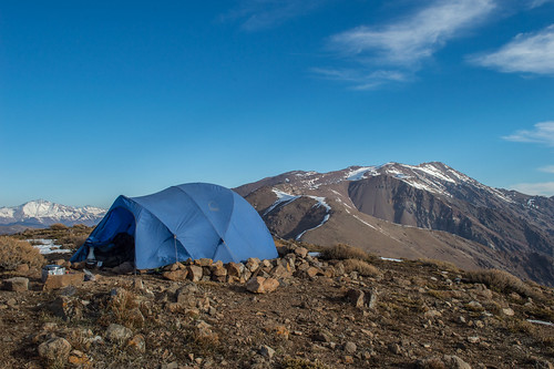
We allowed ourselves 3 days for the traverse, on the first day covering familiar ground on the way to Alto Naranjo and Provincia and pitching our tent at the latter for the night. It ended up being a 6 hour climb, which we thought wasn´t bad at all considering that we were pretty heavily loaded. Setting up camp early in the afternoon had the advantage that we could get some rest while enjoying the spectacular views of nearby
Cerro El Plomo, which we climbed last year, and a dozen or more other peaks between 4000 and 6100m in height, most of which we don´t even know the names of.
 |
| Watching the sunset from our camp site at Cerro Provincia (El Plomo in the background) |
Day 2 started with an 8am descent across a somewhat icy snow field, down again to 2500m, before following the ridge to Morro del Tambor and then all the way to Cerro San Ramón. This was probably the most memorable part of the traverse, the terrain was no longer as steep as the day before and throughout the day we had great views of Santiago to the east, which was slowly emerging from a low level mist, and snow covered mountains of the Andes to the west. At some point the 6500m
Volcán Tupungato came into view at a distance of 60km, and stayed there following us for much of the rest of the day. We made it to Cerro San Ramón at about 1 o´clock in the afternoon.
 |
| On the summit of Cerro San Ramón, with Volcán Tupungato at the distance |
At this point the traverse abandons the ridge and starts descending towards Estero El Manzano, which is a side valley of
Cajon del Maipo. So we didn´t actually make it to the last summit of the ridge, Cerro Punta Damas (one for another trip at some point, maybe).
The descent all the way back to civilization is about 15 or so kilometers long, and given the elevation that needs to be lost in the process this is best spread out over two days. We managed to get ourselves down to 2200m above sea level before the end of day 2 and camped near Los Azules inside a collapsed stone building that still provided shelter from the wind and which once must have been used by local
huasos. The second day was a long one, 8 or 9 hours in total, and our four-legged companions had pretty sore paws by the end of it.
 |
| End of day 2: our camp at Los Azules |
For the third and final day the mission was to get all the way back to the road that goes up the Cajon del Maipo, descending another 1300m or so and crossing the El Manzano creek eight times along the way. At that point the low level mist the sun had managed to burn away the previous day had actually built up into a somewhat thicker layer of clouds, and in those final hours of the hike we were reminded that winter is still putting up a bit of a fight. Back down there it was indeed a bit chilly and miserable again.
 |
| Day 3: descending into the clouds and back to civilization at Estero El Manzano |
Overall a very memorable trip, particularly since we've been toying with the idea of doing it for several years now. A couple more photos
here or in below slideshow:

No comments:
Post a Comment